Mount Baden-Powell

Place Name: Los Angeles County
Place Description: State: California
Date: 05/09/2021
Elevation: 9,399 Feet
Prominence: 2,799 Feet
Miles: 10
Elevation Gain: 3,234 Feet
Lists: Hundred Peaks Section, Hundred Peaks Section Star Emblem
-
Difficulty
-
Solitude
-
Kid Friendly
-
Summit Views
Great Southern California Hike
The north side of the San Gabriel Mountains don’t receive as much love as the south side and that’s fine! That said, Mount Baden-Powell still gets crowded, The views and wilderness feel on this side of the rage are very nice and don’t feel like Southern California at all.
Overall
2.6Pros
- Great views
- Large parking area
- Easy graded trail
Cons
- Lot of switchbacks
- Crowds on the trail
- Can get very windy and cold
While hoards of people flock to the southern side of the San Gabriel Mountains, Mount Baden-Powell sits on the northern end and offers an escape from those crowds.
That said, Mount Baden-Powell isn’t a ghost town. The parking lot at Vincent Gulch will fill up and the Pacific Crest Trail runs right through here. Despite this, I felt like I had much more solitude on this hike than I did while hiking out of Ice House Canyon.
Getting to the Mount Baden-Powell Trail Head is a much a longer drive if you are coming from LA. It starts from Highway 2, the Angeles Crest Highway just west of the town of Wrightwood.
There is a large parking area and bathrooms at the trail head.
The Trail
Switchbacks, switchbacks, and more switchbacks. That is the theme of this trail. From the very beginning you will be climbing, however, the switchbacks make the 2,000 feet of climbing feel trivial. You can really turn and burn on this trail if you want.

Sample of the trail which switchbacks up the mountain.
The other great thing about this trail is the Sierra feel it gives off. I really enjoyed that! The limber ones near the summit are some of the oldest trees in Southern California. Other than that, there is not much to say about the trail. There aren’t many landmarks other than the turnoff to Lamel Spring.
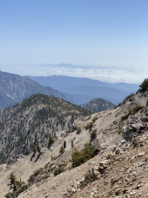
Once you cross the 9,000 foot mark, you will exit the forest onto a ridge line with huge views towards Pine Mountain and Dawson Peak to the east.

View of Pine Mountain, Dawson Peak, and Baldy.
The PCT forks under the summit and connects to the ridge leading over to Mount Burnham, which is a great bonus peak to add onto this hike.

Walking along PCT.
The Summit
Mount Baden-Powell has an enormous summit area. It’s very rounded and has sweeping views, especially towards Mount San Antonio to the south and the Mojave Desert to the north.

On the summit of Mount Baden-Powell.
There is an American Flag flying on the summit and a monument dedicated to Lord Robert Stevenson Smyth Baden-Powell.

Mount Baden-Powell summit memorial.
While I was on the summit, there was a glider plane buzzing the area which was pretty cool. If you would like to add on Mount Burnham, just follow the use trail west off the summit and it will connect to the PCT and lead you over there. On the return, you won’t need to go over the summit of Baden-Powell again,

Looking towards Mount Burnham.
The Final Word
Even though this is one of the most popular mountains in Southern California, I thoroughly enjoyed it. The northern side of the San Gabriel Mountains just feels wilder than the southern end and will keep me coming back to them to explore other peaks.
If you are looking for a fun and moderate hike, this one should fit that bill for you. Give it a look!