North Peak

Place Name: Mono County
Place Description: State: California
Date: 8/14/2021
Elevation: 12,242Feet
Prominence: 682 Feet
Miles: 9.6
Elevation Gain: 2,117 Feet
Lists: Sierra Sampler, Sierra Peaks Section, Western States Climbers Emblem, Vagmarken Sierra Crest
-
Difficulty
-
Solitude
-
Kid Friendly
-
Summit Views
A Wow Hike
Sometimes you embark on a hike and what you have previously read about it does not do it justice. Sometimes you just need to lay your eyes on it and say “Wow!
That is the Conness Lakes Basin and North Peak hike summed up in one word.
Overall
3.3Pros
- Moderate trail walking
- Running water and lakes all over
- Amazing summit area
Cons
- Very exposed to sun
- Would be tough to combine with Mount Conness
- Would probably be wet and muddy in spring
Sometimes a trail or a mountain just knocks you upside the head and makes you say “Wow!” That trail is the North Peak Trail via the Conness Lakes Basin.
If hiking through meadows below towering granite peaks, past multiple glacial lakes, and to amazing summit views, this is the trail for you.
Getting There
Access to the trail is very easy. From Highway 120, just east of the Yosemite entrance and top of Tioga Pass, take the signed Saddlebag Lake Rd.
Follow this graded dirt road all the way to the dam of Saddlebag Lake where there is a trailhead sign, bathrooms, and parking.
The Trail
For starters, this trail can be started by walking across the dam of Saddlebag Lake and then following the trail just above the left shoreline. This section can also be bypassed by paying for a ferry boat at the Saddlebag Lake Resort. This will take you all the way to the northern shoreline and save about 1.5 miles each way.

The trail along the side of Saddlebag Lake.
After turning away from Saddlebag Lake, the trail passes the beautiful Greenstone Lake and follows a steam through the lush meadows before starting to climb up a granite ridge.

Greenstone Lake
This leads into another small valley made mostly of granite and eventually gives way to the first of the lakes in Conness Lakes chain.

North Peak from the second valley on the hike.
The waters are beautiful and trout were jumping all over the place. To exit the lake, there is a little handsy class 2 section to get around a rock that drops straight into the lake.

The first Conness Lake with Mount Conness reflecting in it
Follow the lake shore up into a talus field that has a creek flowing underneath it and aim for the narrow passage that creek comes through. This rocky passage may be impassable during the runoff season, it’s narrow.

Headed through the narrow pass to the upper Conness Lake.
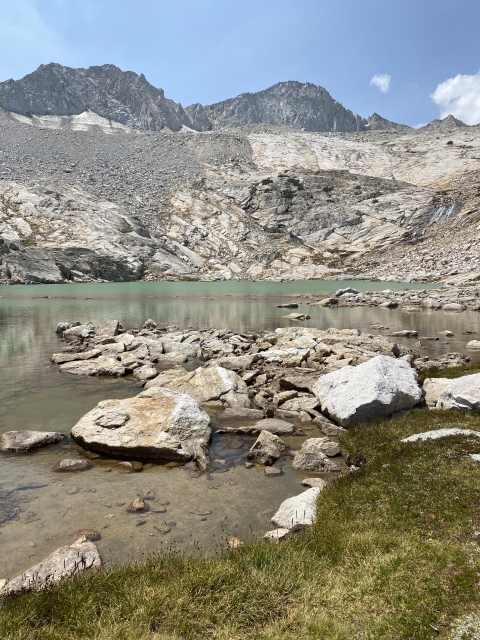
When you pass through, you are greeted with the next lake in the group and it’s gorgeous turquoise waters.

Conness Lake
Follow the lake shore to the right and pick up the use trail that starts up towards the ridge. The trail gets very steep in this section, however, for the most part is easy to follow up to the ridge.

Trail headed up towards ridge from the upper Conness Lake.
Once you crest over the ridge, you will enter a high granite plateau with great views towards the summit, across the valley to Sheep Peak, and of course towards Mount Conness.

On the high plateau between Mount Conness and North Peak.
The Summit
Climbing to the summit is a few hundred feet from here and the use trails disappears. There are good sized boulders to hop around and over, however, none if these are that difficult. Just pick a line and it will probably go.

Final summit scramble. Easy peasy.
Once arriving at the summit, take in the amazing views. You can see Mount Conness, Conness Glacier, and the Conness Lakes Basin you just hiked through. The Twenty Lakes Basin is highly visible below with other peaks like Mount Warren, Dunderberg Peak, Mount Dana, and Matterhorn clearly visible.

North Peak summit views to the north.
Looking back to the west, Mount Hoffmann, Roosevelt Lake, and Half Dome make up the most visible landmarks.

North Peak summit views west towards Mount Hoffmann. Roosevelt Lake below.
The Final Word
What can I say again but “Wow!” This hike has it all. Lakes, streams, summit views, and an awesome looking mountain. You will have a hard time finding a better hike in California. The best part, it’s not very difficult.
Even if just hanging out at the lakes is your fancy, this will be a fantastic day! Go on now, give it a try!