Raymond Peak

Place Name: Alpine County
Place Description: State: California
Date: 09/07/2020
Elevation: 10,014 Feet
Prominence: 1,282 Feet
Miles: 11.8
Elevation Gain: 3,127 Feet
Lists: Tahoe-Ogul, Western States Climbers
-
Difficulty
-
Solitude
-
Kid Friendly
-
Summit Views
A Volcanic Gem In The Middle Of The Wilderness
Raymond Peak is a very prominent fixture on the skyline in the Carson Pass, Ebett’s Pass, and Gardnerville areas. It’s jagged looking spine is visible from many miles and begs to be climbed. Despite that, most people simply pass by it on the PCT or hang out below in Raymond Lake. The steep and slippery push to the top is well worth the extra energy to play around on class 3 summit.
Overall
2.9Pros
- PCT is beautiful in this area
- Raymond Lake is close
- Good road access to trail
Cons
- Can be busy on summer weekends
- Very susceptible are to thunder storms
- Loose terrain once off trail
Standing over 10,000 feet between Carson Pass and Ebbett’s Pass, Raymond Peak may not jump out to you at first. However, if you have driven both of those roads, you have seen it.
The rugged volcanic slopes of Raymond Peak are a prominent fixture in the region and can be seen from the Gardnerville area in Nevada. I have spent my whole life visiting this area and never heard of the mountain until I started peak bagging and chasing the Tahoe Ogul List. Once I took notice, the jagged spine of this mountain was ever inviting.
With the amount of entries in the register, Raymond Peak definitely gets more traffic than I imagined.
Getting There
Raymond Peak is accessed from the Pacific Crest Trail, making it accessible from Ebbett’s Pass on Highway 4 or from Blue Lakes Road off of Highway 88. The approach is much shorter coming from Highway 88.
As you drop into Hope Valley on eastbound 88, you will see the sign for Blue Lakes Road. This paved two lane road heads back to multiple lakes and campgrounds. Just before you reach the Blue Lakes area, you will see a dirt road to the left that is marked as Sunset Lake Rd. This road goes back a few miles and is well graded, 2WD accessible. Pass by Tamarack Lake and follow it to a T-junction. The left road goes down to Sunset Lake.
The right road heads towards Wet Meadows Reservoir. Take the road to the right and follow it past Wet Meadows and into the forest. This will eventually dead end near a trail head sign. You will more than likely need high clearance to get this far, but 4WD is not necessary in dry conditions.

Parking area.
The Trail
The trail starts out along a creek and passes a Mokelumne Wilderness sign before connecting to the PCT. From here, the task is easy – follow the PCT until you reach the junction for Raymond Lake.
This section of the PCT is beautiful. After walking through the forest you start climbing up the open ridges and the trail circumnavigates the volcanic sides of a large canyon.

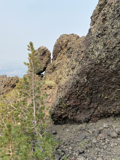
The PCT curves its way through the volcanic landscape.
After another forested section, you bust out above the tree line and gain another ridge. This one is littered with mules ears and large volcanic rock formations.
Along this ridge you will come to a post that junctions the PCT to the left and Raymond Lake to the right. Again, this is all easy trail to follow. To get to the peak, you will cut off trail before the lake.

PCT Junction with Raymond Lake Trail.
It’s probably wise to have a pre-saved GPS track to know where to cut off, but it’s pretty easy to find. Where the trail makes a huge bend, just make a left and start up the dry creek bed.

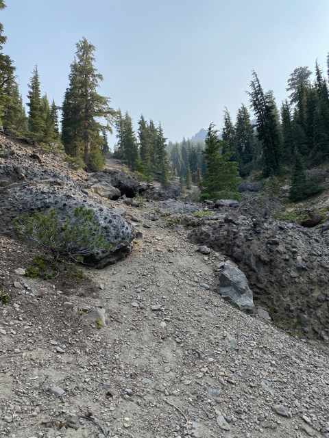
Break off the trail here.
The cross country section gains over 1100 feet in 0.6 miles and a lot of soft dirt makes it “fun”. The bottom part of this is under the cover of trees which you can use to assist your climb. The ascent steepens and loosens a bit as you head towards the large volcanic rocks that make up the summit.

The summit area comes into view.
The Summit
I found a small little pass that cut over the crest to the west side and followed that underneath the rocks before finding a nice slope back to the west. This gives access to the summit area.

Terrain heading up to the ridge and small pass. Very slippery.
I have read a lot about the class 3 summit, but I only needed a couple easy class 3 moves along this entire trek. It’s mostly class 2. Although, if you are more adventurous than me, one can spice this up and turn it into some class 3 and 4 with varying grades of exposure.
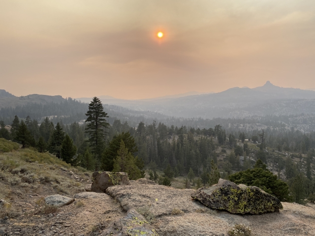
Unfortunately wild fire smoke was terrible on this day, so our views were hampered drastically. I can only imagine they are quite amazing.

Looking down on Raymond Lake with Thornburg Canyon behind.
On the descent, we decided to visit the lake for some trout fishing and descended down the slopes straight to the lake. This was a very steep and sandy descent but can be done quickly and easily with some plunge steps.
The Final Word
Raymond Peak is a fun mountain depending on who you talk to. Personally I found it very enjoyable, if you ask my friend, you will get a much different answer.
It offers a little bit of everything for anyone that wants to hike it. I definitely recommend taking some time to spend at the lake and there are even some great campsites there if you wish to make it a weekend trip.
This area does see a lot of foot traffic from the nearby PCT and is even popular for PCT section hikers that elect to hike between the two passes. It’s also an area prone to thunderstorms in the summer. They come in fast an violently. My first try for this peak I was chased away from these and my second trip was cancelled the night before because of the forecast. I highly recommend an early start.

View back towards Raymond Peak with rain clouds.
Some people link up the other nearby Ogul List Peak (Reynolds) when climbing this one.
If you are looking for a fun weekend getaway with lots of camping and fishing opportunities nearby, this is a great option and I would highly recommend it, even if the peak is not of interest to you. I know I’ll be back!