Sierra Buttes Lookout

Place Name: Sierra County
Place Description: State: California
Date: 07/30/2020
Elevation: 8,590 Feet
Prominence: 1,870 Feet
Miles: 5.7
Elevation Gain: 1,538 Feet
Lists: Tahoe-Ogul, Sierra Sampler, Western States, Sierra Club Peaks Section, Western States Emblem Peaks
-
Difficulty
-
Solitude
-
Kid Friendly
-
Summit Views
Great Trail To The Lookout On Top
A great trail through the forest leads to the rocky buttes and a steep staircase to the lookout.
Overall
2.4Pros
- Great trail and roads
- Beautiful views
- Lots of parking
Cons
- Lots of people
- Steep stairs could give you pause
- Be careful of OHV traffic
The Sierra Buttles Lookout Trail is a popular hiking trail just outside of Sierra City. It’s easy to see why it is so popular once you lay eyes on this beautiful mountain for the first time. They are unlike any other mountain in the region. There is a decommissioned fire lookout tower on the top which is made easy by the steep staircases on the west side. The views from the summit are phenomenal and the hike to get there is moderate.
Getting There
I’m not very familiar with the area and only know the main way in. There appear to be multiple roads you can drive to get to spot and other trail heads to access the lookout.
The main route is to take Highway 49 and turn north on Gold Lakes Road. You will not be on this road long and will be looking for a left turn onto Packer Lake Rd. (Go Pack Go!). There is a bridge immediately to the left. This road is paved, and we drove it all the way to Packer Saddle. There are a couple of narrow one-lane areas to drive through. You can park at an intersection which appears to be popular for mountain bikers. You can drive another ¼ mile on gravel road to the main trailhead which is signed for Sierra Buttes Lookout.

Road down to the trail head.
That road does continue and is signed for the Sierra Buttes OHV Trail. Later in our hike, we encountered two trucks parked less than a mile from the summit. I’m assuming they came up from this road.
The Trail
Hiking the Sierra Buttes is all on trail and easy to follow. The first half mile is on what looks like an old jeep road. You will then meet a trail junction where is turns to single track. Follow this trail to the right along the ridge.

About 1/2 mile in, you pass a junction and it turns to single track.
We hiked along a nice ridge top with wildflowers that were just starting to bloom. Along this ridge there is a crossing with the PCT. Eventually you will start climbing the western shoulder of the mountains and end up under the canopy of the forest. Check out the giant boulders in this section. They really are awesome.

Giant boulders along the trail.
Around the two-mile mark we came across the 4×4 vehicles and paralleled the road for bit. Eventually, we met up with another road that appeared to be the service road since we could see it was gated about 200 yards down the hill. The rest of the hike is on this old jeep road and it will lead you to the staircase. Apparently, you can take motorized vehicles to this spot. Three dirt bikes pulled up while we were eating lunch.

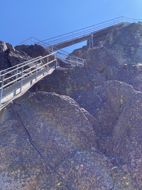
Finally under the tower.
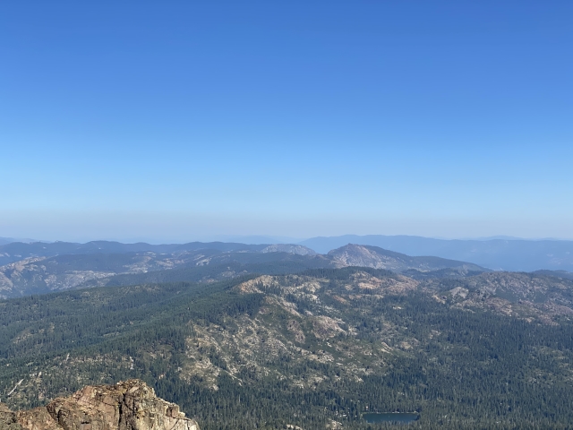
Now that you are just under the tower, it is time to get up there. Staring you down are three flights of very steep stairs, some with exposure underneath them. We took each step slow with the kids and were standing under the lookout in no time. The benchmark is located underneath the tower on the east side. One short set of stairs puts you on the lookout deck. The northeast side has what looks like a 1,000-foot drop directly under your feet. The views were fantastic even with the haze from a wildfire. Soak in the views!


On the lookout platform. Crazy drop underneath!
The Final Word
This was an enjoyable trail to hike in a pretty area, however, it is a highly traveled area. We visited on a Thursday and there were many hikers, campers, and bikers in the area. I can only imagine how busy it gets on the weekend.
That said, this is still a must-do trail if you are living in Northern California. If you have time, drive over to Haskell Peak and take in that great trail as well.