Spirit Mountain

Place Name: Clark County
Place Description: State: Nevada
Date: 12/07/2020
Elevation: 5,639 Feet
Prominence: 2,879 Feet
Miles: 4.7
Elevation Gain: 2,684 Feet
Lists: Desert Peaks Section, Great Basin Peaks, Desert Summits Book, Las Vegas Mountaineers Classics, Nevada Peaks Club
-
Difficulty
-
Solitude
-
Kid Friendly
-
Summit Views
A Hidden Gem In The Desert
Spirit Mountain is like an island of rugged granite in the sea of nothingness that makes up this part of Nevada. This desert hike should not be overlooked and it really packs a punch in a small amount of miles.
Overall
3Pros
- Amazing views
- Good access road
- Use trail is evident most of the way
Cons
- Route finding can be tricky
- Short class 3 near summit
- Rugged country
There are many great Vegas area day hikes that are closer to the city, however, Spirit Mountain is the truest desert hike I have done in the area.
Spirit Mountain lies in a wilderness bearing the same name about 20 miles southeast of Searchlight, NV. The jagged granite peaks are unlike anything else in the area making it easy to see why this has been a sacred area for thousands of years.
Getting There
Spirit Mountain lies between US-95 to the west and US-93 to the east. Both highways exit Las Vegas to the south with 95 going to Searchlight and 93 to Kingman, AZ. The easiest approach is from US-95 where you will pass Searchlight and Cal-Nev-Ari.
A well graded dirt road called Christmas Tree Pass Rd. heads east towards Spirit Mountain. This is a good road and only 7.5 miles to the parking are, 35 mph driving for most of it. Enjoy the Christmas decorations that adorn the local desert trees along the drive. I parked at a wilderness boundary sign and started my hike from there.

Parking area at Christmas Tree Pass.
The Trail
From the parking area I started to head north to the first hill. This drops you into a large wash area. On the way in I kind of got off route and went cross country. Coming out, I was able to stay on a nice use trail through here making it much faster.
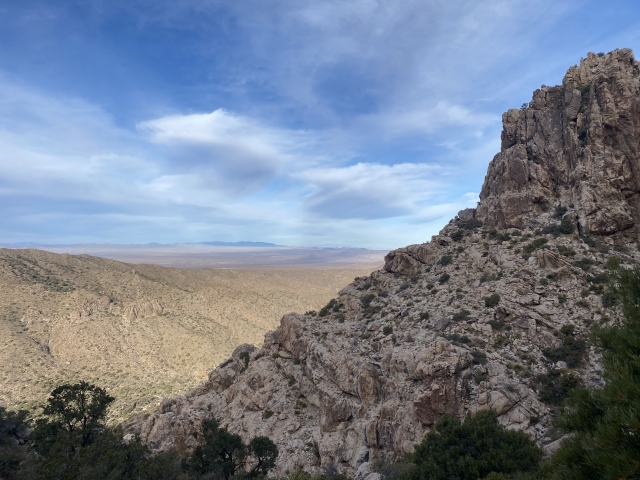
Spirit Mountain is never very far away on this hike and is also very intimidating from below. My first look had me wondering what I was getting into being out there by myself. Once at the base of the mountain, there is a decent use trail that ascends through the rocks.

Start of the Spirit Mountain Trail.
There are lot of cairns to help guide the way and it’s important to keep looking ahead for the next one. I found myself getting of trail often and into some very nasty terrain. The terrain around the trail is not much fun at all with lots of cliffy areas and prickly stuff.

Cairns like this are regularly found.
The trail eventually gains the ridge and goes over to the east side of the range as you work your way towards the summit area. To get to the actual summit area there are two routes, both require a class 3 move. The one I took was a short narrow passage through a larger rock, although it was non-exposed, it was pretty tight with my pack.

Class 3 pass. Had to pass through the crack in the center.
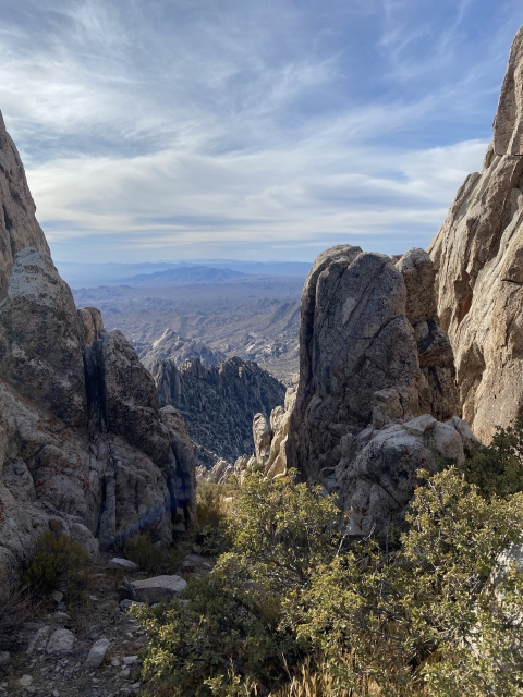
The Summit
After cutting through the rock, it’s just a quick jaunt over to the summit. The views are out of this world! Lake Mojave is to the east, Laughlin to the southeast.

Lake Mojave.
The Spring Mountains with Charleston Peak to the north. With over 2,000 feet of prominence, I felt like I was on my own little island in the desert. It was less than 2.5 miles to the summit, but still took me almost 2 hours to climb.
The Final Word
Spirit Mountain finds itself on a few major peak bagging lists and it’s easy to see why. This area would make a great National Monument. It’s a very special spot.
Don’t take this one lightly, even though the round trip is less than 5 miles, it’s a hard 5 miles. The trail is slippery, prickly, and I’d suspect deathly hot in the summer. It’s also prime rattlesnake country. I was hoping the cold morning temps would keep them dormant and I did not see any.
After returning home, I read about an area called Grapevine Canyon that was one mile further up Christmas Tree Pass Rd. There are lots of petroglyphs and a seasonal waterfall here! I’ll have to return at a later date to check that area out.
I was back in Vegas by 2 p.m. this day and had a major peak knocked off. Not bad for a trip out to Sin City!