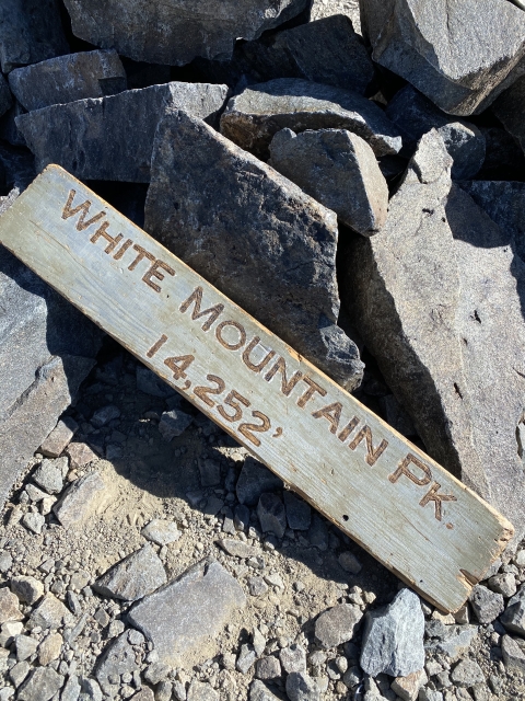
White Mountain Peak

Place Name: Mono County
Place Description: State: California
Date: 07/11/2020
Elevation: 14,246 Feet
Prominence: 7,196 Feet
Miles: 15.4
Elevation Gain: 3,356 Feet
Lists: Great Basin Peak List, Desert Peaks Section, Desert Summit Book, Las Vegas Mountaineers Classic, Western States Climbers Star Peak, California County High Point
-
Difficulty
-
Solitude
-
Kid Friendly
-
Summit Views
California's Easiest 14er!
White Mountain Peak has the reputation of being the easiest of the California 14ers. It’s got a high trailhead and a road walk all the way to the summit Don’t let that discourage you from tackling the summit. The White Mountains are an amazing range and nothing like the Sierras just across the Owens Valley.
Overall
3.1Pros
- Great trail
- Awesome Views
- Easiest 14er
Cons
- Very busy trail
- Long drive in
- Noisy night at camp
White Mountain Peak has the reputation of being the easiest of the California 14ers. It has a high trailhead and a road walk all the way to the summit. Don’t let that discourage you from tackling the summit. The White Mountains are an amazing range and nothing like the Sierras just across the Owens Valley.
This is a classic California hike and a great way to prep for longer hikes like Mount Whitney or Mount Langley.
Getting There
White Mountain Road is the only way to access the peak. From Big Pine, CA, leave Highway 395 by heading east on Highway 168. After around 13 miles, turn left onto White Mountain Rd towards the Ancient Bristlecone Pine Forest. This road is paved for about 9.5 miles just past the Shulman Grove.
From here on out, it’s a dirt/gravel road. While it’s bumpy and will rattle your brain, the road is not tough at all, just long. The Barcroft Gate is 17 miles from the end of pavement.

The drive in along White Mountain Road.
Park and camp here at 11,600 feet in elevation. On the weekends, it may have a music festival tailgate vibe. There is a bathroom up here as well.

Camping area at Barcroft Gate.
The Trail
This hike starts at the Barcroft Gate and follows a very nice dirt road across the high tundra and all the way up to the rocky summit. The trail is super easy to follow and offers unrivaled views of the highlands the entire way. After 2 miles, you will pass through the Barcroft Station at 12,440 feet and then climb up a small hill to enter the high valley ahead of you.
The trail is very gradual through this section and you can see everything laid out in front of you. Each step you take draws closer the summit towering ahead of you.

Trail across the high tundra.
Pass the White Mountains Wilderness sign and gain a ridge line that takes you above 13,000 before dropping down a hill before the final summit climb.

White Mountain Peak Wilderness Sign.
After the drop, the trail starts to switchback up the final 1,200 feet through the rocky terrain and up to the summit. Once I crossed 13,200 feet, my pace started to drop off from my 20 minute mile pace. Take your time and soon will notice that you are just below the hut. Keep following the switchbacks and claim the third highest summit in California.

Getting ready to make the drop and then start ascending White Mountain Peak.

Nearing the summit.
The Summit
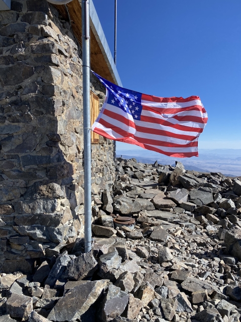
White Mountain Peak has monstrous views in all directions. The summit area has a large stone hut and is very big. If you are lucky, you might get it all to yourself for a bit.

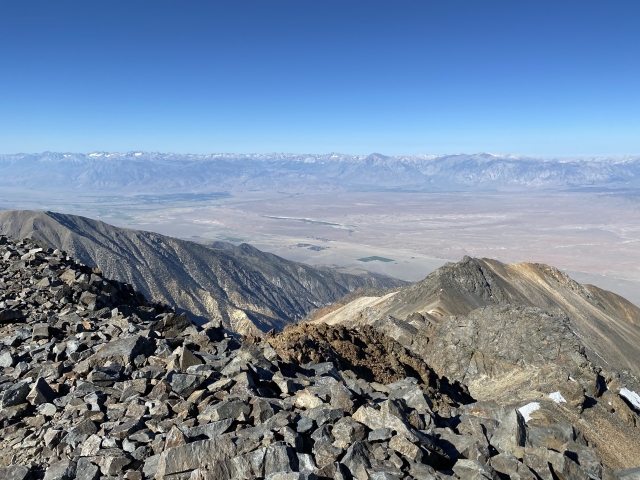
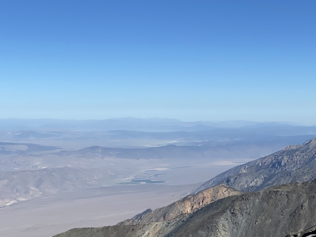
The Sierras sit just across the Owens Valley to the west, the White Mountains extend to the north and the south, and to the east is the Fish Lake Valley and the desert peaks of Nevada. Piper Peak, which I climbed the month before, looks like a mole hill from here.

Looking out towards Bishop.

Views to the east on the way up towards Fish Lake Valley and Piper Peak.
Be sure to take your obligatory picture with the summit sign and reverse the course back to the trailhead. This was my first 14er and I was super stoked to be here. The feeling of accomplishment was amazing and to summit it in under three hours left me feeling proud of my fitness.

White Mountain Peak summit!
The Final Word
If you are looking to knock off a California 14er, this is gonna be the easiest one. With a nice easy road walk to the summit, the terrain can’t get any easier. Although the walking is easy, make sure you are in great shape and can handle the altitude. This is still a 15-mile roundtrip hike that is all above 11,000 feet in elevation.
Always stay hydrated and eat well. Be ready for afternoon thunderstorms. There is nowhere to hide from them.
In addition to White Mountain Peak, there dozens of high elevation summits that require short hikes to bag in the area. They all are back country adventures and get you away from the crowds. The White Mountains are a gorgeous range and should be on your radar to explore.