Grapevine Peak

Place Name: Death Valley National Park
Place Description: State: Nevada
Date: 01/05/2021
Elevation: 8,738 Feet
Prominence: 4,562 Feet
Miles: 7.4
Elevation Gain: 3,222 Feet
Lists: Great Basin, Desert Peaks Section, Nevada Peaks Club, Bartell's Death Valley List, Desert Summit's Book
-
Difficulty
-
Solitude
-
Kid Friendly
-
Summit Views
A Fun And Obscure Hike In Death Valley
When visiting Death Valley National Park, hiking Grapevine Peak is probably not in the top 20 things to do. You won’t read about it in a park brochure or have a ranger recommend it. It’s a true high desert back country hike off the beaten path in the Nevada Triangle area of the park.
Overall
3.5Pros
- Moderate hike
- Huge views in all directions
- Road is manageable
Cons
- Long drive in on dirt
- Far away from the rest of the park attractions
- Antenna on summit
Grapevine Peak probably doesn’t make the top 20 list when thinking of Death Valley National Park and all of its amazing attractions.
For peak baggers however, Grapevine finds itself on many key lists and boasts an impressive 4500 feet of prominence. Located north of Beatty, NV, Grapevine Peak doesn’t receive a lot of visitors despite being a worthy attraction.
Getting There
Despite being located in the National Park, getting to Grapevine Peak is a long and tedious journey. It’s nowhere near any park entrance and the closest town is Beatty to the south. To get to Grapevine Peak, you need to exit US-95 onto the dirt Phinney Canyon Rd. One gate will need to be opened and from there, just follow the road out to the range in the distance.

The start of Phinney Canyon Road headed into the Grapevine Mountains.
This road is all dirt and graded well all the way up to the National Park boundary. You can drive 30-40mph. After that, the road is still 2wd, but there are some deeper ruts that could wreak havoc if you have low clearance. Without high clearance, I would be hesitant to drive past the weather station. The road gets a bit worse and descends into the canyon after this stretch.
With 4WD, one could drive all the way to the saddle where there is a great place to camp. We stopped a mile below the end of the road because of snow conditions. The last mile of road gains almost 900 feet and does have a few rock obstacles to crawl over. I’m glad I decided not to push it in the snow.

The parking area at the saddle. With 4×4, you can start here for either Grapevine or Palmer.
The Hike
From where we started hiking on the road, this added an extra 2 miles and 900 feet of gain to the hike. This means with the right conditions and vehicle, you are looking at a mild hike.
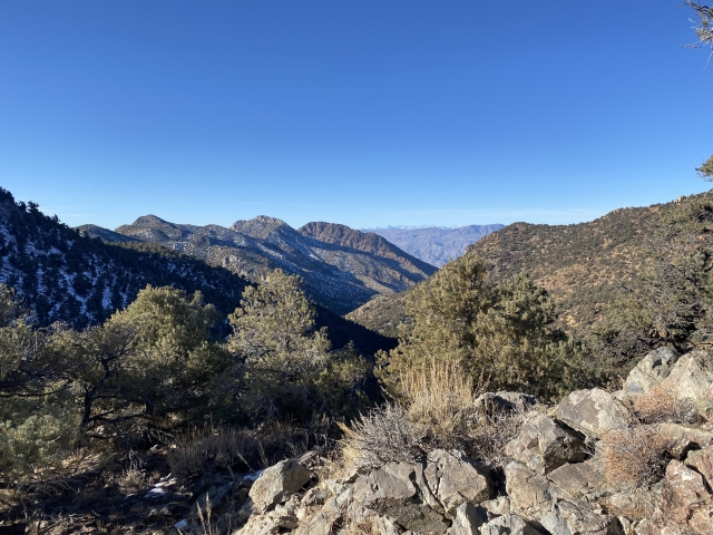
Regardless, after the saddle, there are lots of ups and downs along the ridgeline. The terrain is mostly gentle over the forested ridge with minimal bushwhacking. The entire hike you get the sense that you are a long way from any where and you really are. Surprisingly, I had pretty good Verizon service along most of the hike.

The path has been laid out in front of us. Follow the ridge.
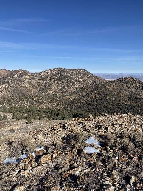
Once you reach the final saddle, there is a nice push to the summit with a short talus field to walk up and then back to easy terrain again all the way to the summit.

Open section leading up to summit.
The Summit
Unfortunately, there is a small radio tower on top which takes a bit away from the experience, but overall the views are unreal. From here, you can see the lowest point in North America at Badwater Basin as well as Mount Whitney, the highest point in the lower 48.
In fact, you can see most of the 14ers along the Sierras, White Mountain Peak, Telescope Peak, and Charleston Peak. Looking the other way, Arc Dome is visible and peaks in the world famous closed off part of Nevada.

Another Great Basin Peak knocked off!
As expected, the summit register was filled with hardcore peak baggers only. Grapevine Peak is no National Park tourist trap.
The Final Word
I really enjoyed this trip and hike. When I first got into peak bagging, this one stuck out to me for some reason. There are actually three worthy peaks that can be hiked from this approach – Grapevine, Palmer, and Wahguye. We had thoughts of tagging the very steep and short Wahguye afterwards, but the north facing slope was snow covered and very icy looking.

Wahguye Peak
This would make a great two-day camping trip to tag all three of these and I’m planning to return in the future to bag the others.
If remoteness is what you like, the Grapevine Mountains and the Nevada Triangle of Death Valley National Park offer it!