Last Chance Mountain

Place Name: Death Valley National Park
Place Description: State: California
Date: 04/08/2021
Elevation: 8,456 Feet
Prominence: 2,376 Feet
Miles: 7.5
Elevation Gain: 3,032 Feet
Lists: Desert Peaks Section, Desert Summits Book Peak List, Bartell's Death Valley NP List
-
Difficulty
-
Solitude
-
Kid Friendly
-
Summit Views
A High Desert Gem In Death Valley NP
When most people think of Death Valley, climbing mountains is probably pretty far down that list. Even further down the list would be Last Chance Mountain. This summit sees only a handful of visitors per year and all of those would be hearty peak baggers chasing the DPS List. Once you start climbing, this peak loses a bit of its desert feel and makes for a fantastic half day hike.
Overall
3.3Pros
- Good access road
- Great views
- Won’t see anyone else
Cons
- No trails
- Snake country
- Would be hot in summer
As far as mountains go in Death Valley National Park, they don’t get much more obscure than Last Chance Mountain.
Standing at 8,456 feet and over 2,300 feet of prominence, Last Chance Mountain is a very nice peak to climb and not all that difficult. With the Eureka Dunes nearby and many other summits in the area, this is a great spot to spend a couple of days.
Getting There
Like most obscure summits in Death Valley, it takes a bit if back country driving to get there. As always, be prepared when driving out here. Always carry way more water than you will ever need, extra gasoline, spare tires, flat tire repair, and an emergency satellite beacon.
The best way to get here is by leaving Highway 395 in the town of Big Pine onto Highway 168. Follow this highway east for about two miles and turn right onto the well signed Death Valley Rd.
This road is mostly paved and yo can drive at decent speeds until it reaches Eureka Valley about 40 miles later. The road across the valley is heavily washboarded and needs to be scraped badly. You can’t drive much faster than 5 mph on some of it.
If you turn right, you can head into the Eureka Sand Dunes and a campground at the foot of them. This makes a great basecamp with fire pits and toilet. The dunes are worth the visit out here alone.
Once you cross the valley, the road becomes paved again. After a few miles, it turns to dirt once again and you will make a left onto a road into a Sulphur mine. This road is in ok shape and 4×4 is not required. After about 3 miles you will come to a giant mine tunnel in the side of the mountain. The road does continue on a bit, but it’s just as easy to park here and walk.

Parking area.
The Trail
Like many of these peaks, there is no official trail. However, there are two routes to climb Last Chance Mountain. From the south like I did or from the east at Last Chance Spring.
Coming up from the south, we followed the old road up to where it becomes impassable and started to climb up through some class 2 rock towards the ridge line. From the mine, any car could drive another 1/2 mile in. There is washout section at this point, however, a good 4×4 could get past it. Doing so would save another 1/4 mile at the most.

Some of the road past the mine.
Once the ridge is gained, a nice use trail will appear and follow the ups and downs.

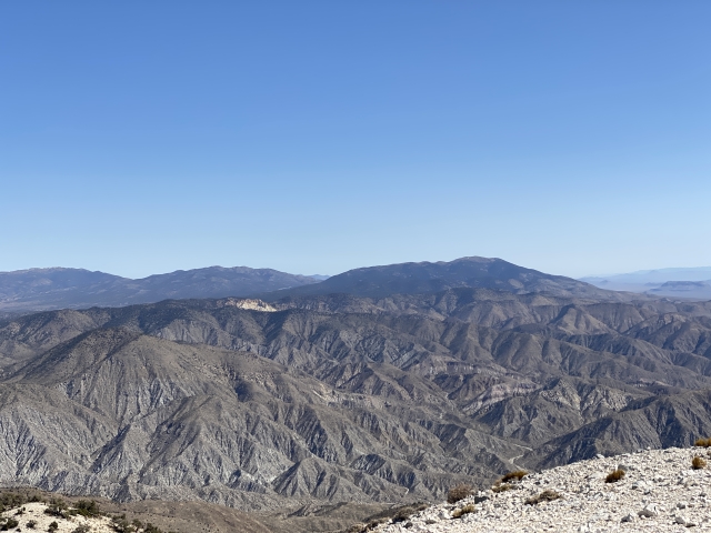
Looking west at the ridge line traverse towards the summit.
There are 3 fairly significant bumps along the ridge that you must go up and over. A lot of this hike does have forest cover which is a nice change for the desert.

Along the hike to Last Chance Mountain.
Continue following the ridge as it leads towards the long summit area.
The Summit
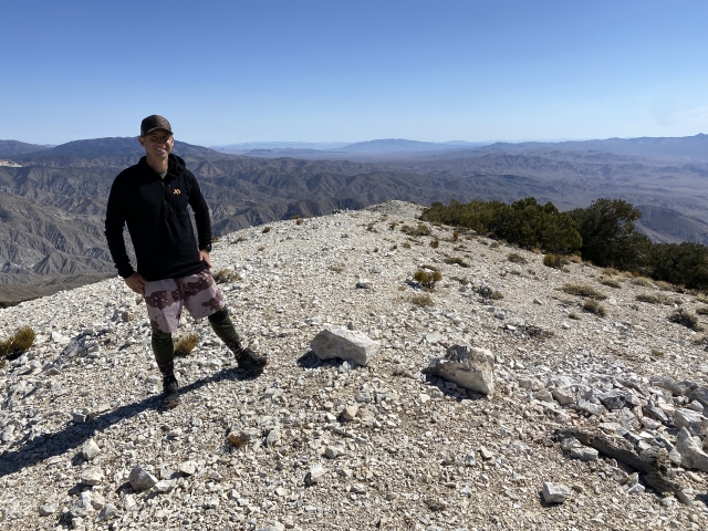
After walking the ridge, the final push up to the summit is rather easy as the ridge just continues on towards the high point. There is a summit cairn and register at the top.

On the summit of Last Chance Mountain.
The views are pretty sweet with Waucoba Mountain looking invincible to the west and the snow covered Sierras beyond it.

Waucoba Mountain across the valley.
To the North, Magruder Mountain and Palmetto Mountain dominate the views. We actually climbed these both later in the day.

Magruder Mountain (Middle Right) and Palmetto Mountain (Upper Left).
The Final Word
Last Chance Mountain was a quick and fun peak. The entire hike reminded me a lot of the terrain and style of hiking I encountered on Grapevine Peak. For being a desert peak, there is surprisingly a lot of shade along the hike which was nice as the sun was bright all morning.
If you are looking to explore the Eureka Valley, hiking up Last Chance Mountain and even Sandy Point just across the road to the south, are both great options.
During our trip, we also tagged Sandy Point, Magruder Mountain, Palmetto Mountain, Sylvania Mountain, and Chocolate Mountain. This made for an adventurous 3-days in the high deserts of northern Death Valley National Park.


 and Palmetto Mountain (Upper Left).")


